
C H A P T E R
N ° 28
Avionics and Mitigation Measures (Part 1)
The aviation industry is within the top five sectors and industries most at risk from space weather impact. This is because of its heavy reliance on technology and infrastructure that can be disrupted by solar activities.
Solar activities can create space weather which can influence the performance and reliability of space-borne and ground-based technological systems and can, in some cases, even endanger human life or health.
The aviation industry is becoming more aware of the impact of space weather on flight operations due to the increase of cross-polar traffic. The industry is primarily concerned about risks during high-latitude (>50°N) and polar operations (>78°N). This is due to the South Atlantic Anomaly (SAA). Earth’s magnetic field is not truly dipolar in space or at the Earth’s surface. The internal magnetic field has a depression centered over the South Atlantic, which is known as the South Atlantic Anomaly (SAA). Solar activity causing a certain level of space weather can bring the magnetic field of Earth closer to the planet in this region. This means, that aircrafts flying only a few hundred kilometers above the mean surface level of Earth can experience exposure to a substantial radiation dose. The risks of space weather impact on aircrafts, pilots, and crew is, thus, the highest in these regions.
The industry has been subject to space weather impact numerous times with significant economic losses. In 2005, the total cost of extra fuel used to reroute aeroplanes from polar routes due to space weather amounted to approximately 186 million USD. This was excluding costs to passengers and compensation. The increased cross-polar traffic and economic losses makes space weather a recognized natural hazard within this critical infrastructure.
In Hoplon’ article C H A P T E R N ° 27, we provided a short introduction to the relation between space weather and the aviation industry, starting by exploring the interaction between space weather and the Earth’s natural planetary defence systems, and how they are connected to the potential space weather effects on the aviation industry. Additionally, we investigated the interdependencies between certain critical infrastructures and how this increased the risk and vulnerability to space weather impact on the aviation industry. The article ended with a short discussion providing some examples of the risks and effects experienced by the industry from space weather impact.
Space weather can affect aircrafts in various ways. Today’s article will be the first of two articles focused on avionics and mitigation measures. In both articles, we will look closer at how space weather interacts and affects avionics. Additionally, we will introduce some of the currently available mitigation measures. Lastly, we will explore some of the financial impact space weather already have had or could have on the aviation industry.

Image Credit: ATR.

Image Credit: ATR.

Image Credit: ATR.
Air transportation is highly sensitive to space weather effects and can be affected in various ways. Impact on the avionic systems and procedures include, but are not limited to: High-Frequency (HF) communication blackouts, satellite navigation failure, and surveillance failure.
High-Frequency (HF) communication
The primary channel used for communication between pilots and aviation staff at ground stations are Very High-Frequency radio (VHF), more specifically the Aircraft Communications Addressing and Reporting System (ACARS, 131.550 MHz). This communication frequency level is used to communicate with airline dispatchers, which are the ones assisting in planning flight paths by for example taking into account aircraft performance and loading, enroute winds, thunderstorm and turbulence forecasts, airspace restrictions, and airport conditions. In addition, communication between pilots and Air Traffic Control Officers are facilitated through the Controller Pilot Data Link Communication (CPDLC) at 118.000-136.975 MHz.
Satellite communication (using orbiting satellites to relay signals) is unavailable north of 82°N, due to the orbit inclination of geostationary satellites. This means, when aircrafts fly over the polar region, High-Frequency radio becomes the only means of communication. However, Earth-directed space weather caused by coronal mass ejections (CMEs), or solar flares bursting intense electromagnetic radiation from the Sun’s surface, can cause ionization within the D-region in the atmospheric layer of Earth named ‘ionosphere’.
This ionization can cause Polar Cap Absorption (PCA) events, leading to distortion and blockage of signals, consequently causing High-Frequency radio communication blackouts and failures for aeroplanes flying north of 82°N. High-Frequency radio communication blackouts can cause significant effects on aeroplane operations.
* High Frequency (HF) communication and satellite communication are distinct technologies. While both can be used for long-distance communication, they operate on different principles and have different characteristics. HF relies on radio waves bouncing off the ionosphere to transmit signals over long distances, while satellite communication uses orbiting satellites to relay signals. *
The 2003 Halloween Storm and 2017 September Storm
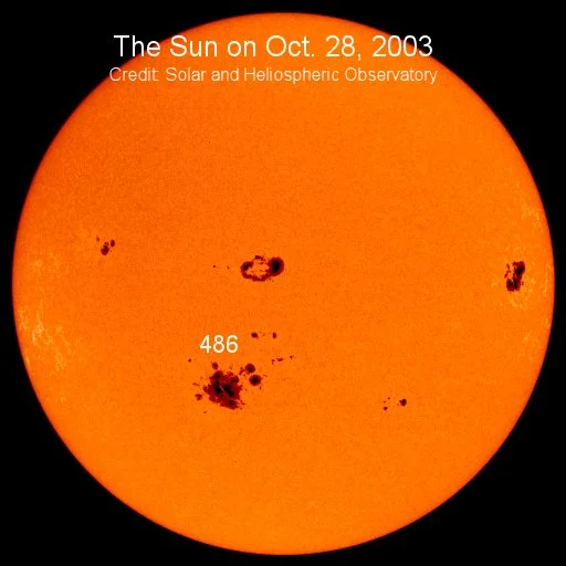
Image Credit: Andreas Walker: The Sun and sunspot Region 486 shown during the 2003 Halloween storm.
The 2003 Halloween storm and the 2017 September space weather event are testimonies showing the potential impact of space weather on the aviation industry. On the 19’th of October 2003 - a few days before the Halloween storm picked (28-29’th of October) – a two hour long High-Frequency radio communication disruption occurred. As a consequence, three polar flights from New York to Hong Kong were forced to reroute to routes with more favourable telecommunications link (Datalink) and satellite communications (SATCOM). This resulted in an additional fuel consumption of approximately 12.066 kg. and a reduction of over 7.530 kg of cargo. Furthermore, as the space weather event was slowly decreasing in intensity, communication reached such a poor state on the 30’th of October, that extra air traffic controllers were required to manage air traffic.
In September 2017, a series of intense solar events comprising solar flares and coronal mass ejections (CMEs) significantly impacted Earth’s space environment and caused a geomagnetic storm disrupting radio communication and affecting the ionosphere. On the 6’th of September, a record-breaking X9.3-class solar flare erupted and travelled towards Earth. During this time, a notable outage of High-Frequency (HF) radio communication occurred in the morning and lasted towards the early afternoon. This caused the French civil aviation authorities to report a 90-minute loss of High-Frequency radio contact with an aeroplane located around the coasts of Brazil and French Guiana, due to it lacking Controller Pilot Data Link Communications (CPDLC) equipment.
* Controller Pilot Data Link Communications (CPDLC) equipment is a technology that is used as a supplement to traditional radio traffic with text-based messages. It is a key component of the Future Air Navigation System (FANS), which is a new way of communicating within avionics. *
Using these events and utilizing 2019 polar flight data, researchers such as Dr. Dabin Xue from the University of New South Wales have tried to estimate the economic loss based on the assumption of a one-day duration blackout of High-Frequency radio communication. If all polar flights were canceled, the calculated loss were estimated to be 2.20 million euros. If only calculating the financial loss of the daily count of 18 polar flights crossing the north polar region above the 82°N, the estimated loss of only cancellations, rerouting, and scheduling adjustments would result in an approximate economic loss of 2.290 million euros.
* To learn more about the relation between space weather and the Earth’s atmospheric layers and the aviation industry, please read: C H A P T E R N ° 13 & 27. *
Mitigation measures
Mitigating High-Frequency (HF) radio communication loss in aviation involves proactive measures and procedures to maintain situational awareness and safety during communication outages. This includes using backup communication methods, ensuring proper transponder settings, and adhering to established procedures for managing loss of communication scenarios.
Aircrafts are generally not allowed to take-off without Air Traffic Control (ATC) clearance. If High-Frequency (HF) radio communication is not available, pilots cannot receive the clearance and are, thus, forced to stay on the ground. If communication is lost after take-off, pilots will have to follow established procedures. If a coded radar beacon transponder is functional, pilots have to change the transponder to reply on Mode A/3 with the code ‘Squawk 7600’, to indicate a communication failure, and will proceed to their planned route or a suitable landing airport.
* Squawk is a term used when Air Traffic Control (ATC) and pilots sent out a transponder code, e.g.; ‘Squawk 7421’. *
Alternatively, they can try to switch to alternate frequencies to contact Flight Service (FSS) or Aeronautical Radio, Inc. (ARINC). Aeronautical Radio, Inc. (ARNIC) is a company that develops and maintains standards ensuring interoperability and reliable communication between various aircraft systems, both on-board and with ground support.
Satellite navigation failure
The Global Navigation Satellite System (GNSS), such as Global Positioning System (GPS) and Galileo, enables the Area Navigation (RNAV) capability, enhancing flight efficiency and a reduction in fuel consumption by reducing the distance between operating aeroplanes. The Area Navigation (RNAV) is a navigation method enabling closer flight paths by allowing aeroplane operations along any desired flight path compared to fixed point-to-point routes defined by ground-based support. Additionally, satellite navigation services support facilitating continuous guidance to pilots towards landing airports and adjustments of speeds to synchronize with other arriving aeroplanes.
Satellites providing global navigation services are found in the second and third orbital pathways around Earth; i.e., Medium Earth orbit (MEO) and Geosynchronous Earth Orbit (GEO).
The Medium Earth Orbit (MEO)
The Medium Earth Orbit (MEO) is located in the ‘slot’ region (i.e., the ‘safe’ region) of the inner and outer Van Allen radiation belts and is not restricted to one path around Earth. The Van Allen Radiation belts is one of Earth’s shielding mechanisms, whereby it traps incoming space radiation. These trapped radiation particles create two zones of energetic charged (ionizing) particles, consequently forming an inner and outer radiation belt around the planet.
Between Earth and the inner radiation belt, and between the inner and outer belts, empty ‘slot’ regions can be found. The Medium Earth Orbit (MEO) is located within one of these regions. However, the slot regions are complex regions and are primarily dominated by electrons.
During Geomagnetic Storms, the outer belt often seems to expand inwards toward the inner belt and, thus, completely filles in the slot region with lower-energy electrons, consequently creating one huge radiation belt. This means, that, whereas the satellites located in Medium Earth Orbit (MEO) would usually be within the ‘safe region’, this is not the case during certain space weather events.
The intensity level of Galactic Cosmic Rays (GCRs) surrounding Earth is dependent on the Sun’s 11-year solar cycle. When the activity on the Sun is the highest (i.e., during solar maximum) enhanced number of particles and complex interplanetary magnetic fields interact with the already present Galactic Cosmic Rays (GCRs) in the near-Earth space environment and, thus, within the Van Allen Belts. During this process, the Solar Energetic Particles (SEPs) enhances the overall energy level of the particles within the slot region. This can produce momentarily high radiation levels and exposure lasting from hours to several days, making the space environment in Medium Earth Orbit (MEO) more hazardous. However, as the magnetosphere of Earth gets weaker the further away an object is to the planet, satellites in Medium Earth Orbit (MEO) are more vulnerable to space weather impact and generally space radiation than Low Earth Orbit (LEO), which is the closest orbital pathway to Earth.
The Geosynchronous Earth Orbit (GEO):
The Geosynchronous Earth Orbit (GEO) is located within the outer Van Allen radiation belt and has an orbital path around the equator of Earth.
The Earth’s magnetosphere provides less protection from space radiation the further away an object is from the planet. Due to this, the outer Van Allen belt is dominated by Solar Energetic Particles (SEPs) originating from the Sun. Objects located within the outer radiation belt and, thus, Geosynchronous Earth Orbit (GEO), are, therefore, the most susceptible of the three most commonly used orbital classes to space weather impact.
The outer Van Allen belt is dominated by Solar Energetic Particles (SEPs) originating from the Solar Wind. The Solar Wind is a continues flow of plasma and, thus, charged particles from the Sun into the outer space environment. The speed, pressure, and magnetic field of the Solar Wind can change rapidly depending on solar activity. The ‘wind’ is created by the outward expansion of plasma from the Sun’s corona (i.e., its outermost atmosphere). This plasma is continually heated to a point where the gravity of the Sun no longer can hold it down and eventually releases it, consequently creating the constant stream of ‘wind’ into the Solar System. As the magnetic field lines furthest away from Earth are weaker compared to those closer to the planet, it enables Solar Energetic Particles (SEPs) to directly interact and affect satellites in Geosynchronous Earth Orbit (GEO).
During solar activities such as solar flares and coronal mass ejections (CMEs), particles are, however, accelerated to much higher energy levels than that found in the Solar Wind – This is not to be confused with High-Speed Solar Wind Steams (HSS). When Earth-directed, these particles interact with the outer radiation belt, causing the particles within this belt to have a higher average energy level. If strong enough, the particles can penetrate through the outer belt and interact with the slot region of the Van Allen Belts, creating one big outer belt. An example is during space weather events like Geomagnetic Storms. Here, the outer belt often seems to expand inwards toward the inner belt and, thus, completely fills in the slot region with lower-energy electrons, consequently creating one huge radiation belt. This means that, whereas the satellites located in Medium Earth Orbit (MEO) would usually be within the ‘safe region’, this is not the case during certain space weather events. Additionally, the space radiation environment in Geosynchronous Earth Orbit (GEO) gets more hazardous, due to the increased energy level of the particles. This increases the risk of certain types of impact on satellites within this orbital class.
One of these effects are the performance of satellite navigation systems, as they can be significantly compromised by space weather, posing safety risks to flights relying on satellite navigation. Additionally, it could cause a reduction in airspace capacity, causing imbalances between flight demand and airport capacity.
* To learn more about the relation between space weather and satellites, and different orbital classes, please read: C H A P T E R N ° 8-11. *
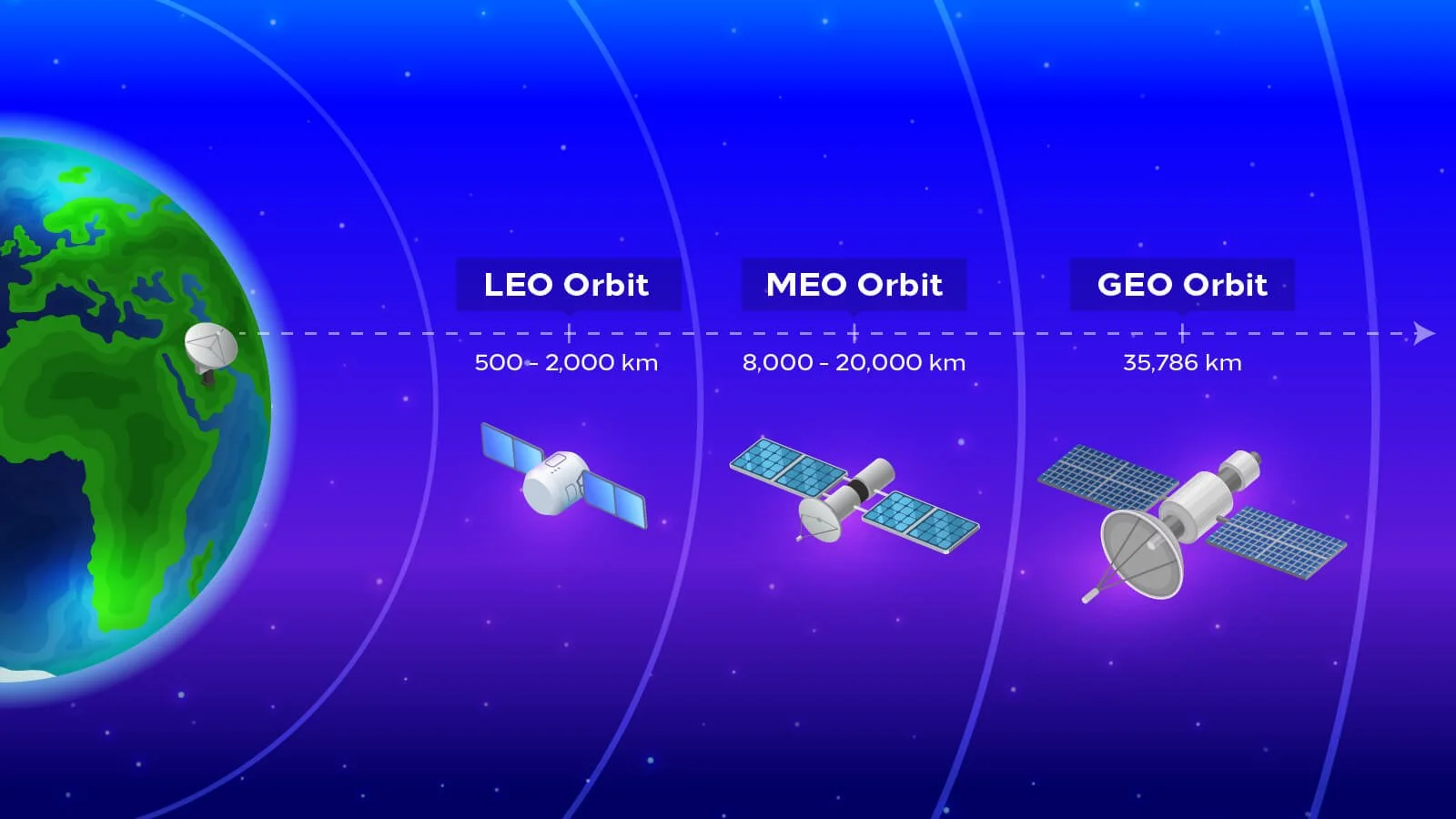
Image Credit: Communications, Space & Technology Commission: showing Low Earth Orbit (LEO), Medium Earth Orbit (MEO), and Geosynchronous Earth Orbit (GEO).
Simulated satellite navigation failure in Hong Kong Airport:
In 2023, Dr. Dabin Xue et al. used forecasted flight data to conduct simulations of satellite navigation failure in Hong Kong Airport in 2030 to examine potential economic losses. They found that taking in parameters such as cancellations, ground delays, airborne delays, and flight diversions the estimated economic loss would amount to approximately 3.18-4.18 million euros. Furthermore, Dr. Dabin Xue and his collogues took the research one step further and analyzed the repercussions of the 2003 Halloween storm on the top fifty busiest airports in the Continental United States, looking at Area Navigation failure and Continuous Descent Approach (CDA) failure. Here, estimations indicated an economic loss of 2.43 million euros. Additionally, simulations were made considering the projected flight volume for the Greater Bay Area (GBA) of China in 2025, indicating economic losses of a minimum of 10 million euros. However, this would depend on the duration of the satellite navigation failure and the time intervals for ground navigation-based landings.
* Continuous Descent Approach (CDA) is an aircraft operating technique whereby an aeroplane descends from its cruising altitude to the final approach fix without any level flight segments. *

Image Credit: Medium.
Mitigation measures
When satellite navigation systems are compromised, there are alternative ways to navigate in air. Although satellite navigation services like the Global Positioning System (GPS) and Galileo make a significant difference for flight operations, pilots do currently not rely on this service.
Alternative ground-based navigation systems like Very High-Frequency Omnidirectional Range (VOR), Distance Measuring Equipment (DME), and Non-Directional Beacon (NDB) can be utilized in case of satellite navigation system failures.
However, using these systems could potentially reduce airspace capacity and cause imbalances between flight demand and airport capacity. Additionally, these back-up systems are expensive to maintain.
According to a report published in 2019, sponsored by the U.S. National Institute of Standards and Technology, losing satellite navigation systems in aviation would cost the U.S. economy approximately 1 billion USD per day. The loss would increase fuel consumption due to longer flight routes, flight delays and cancellations, and potential safety risks, such as midair collisions. The disruption would result in financial losses for airlines, airports, and related industries.
To be continued …
Source
Acharya, S., Dvorkin, Y., Pandžić, H., & Karri, R. (2020). Cybersecurity of smart electric vehicle charging: A power grid perspective. IEEE Access, 8, 214434–214453. https://doi.org/10.1109/ACCESS.2020.3041074
Ali, B. S., Ochieng, W., Majumdar, A., Schuster, W., & Chiew, T. K. (2014). ADS-B system failure modes and models. Journal of Navigation, 67(6), 995–1017. https://doi.org/10.1017/S037346331400037X
Dyer, A., Hands, A., Ryden, K., Dyer, C., Flintoft, I., & Ruffenach, A. (2020). Single-event effects in ground-level infrastructure during extreme ground-level enhancements. IEEE Transactions on Nuclear Science, 67(6), 1139–1143. https://doi.org/10.1109/TNS.2020.2975838
Dyer, C., Lei, F., Clucas, S., Smart, D., & Shea, M.(2003). Solar particle enhancements of single-event effect rates at aircraft altitudes. IEEE Transactions on Nuclear Science, 50(6), 2038–2045. https://doi.org/10.1109/TNS.2003.821375
Enge, P., Enge, N., Walter, T., & Eldredge, L.(2015). Aviation benefits from satellite navigation. New Space, 3(1), 19–35. https://doi.org/10.1089/space.2014.0011
European Commission (2016): “Space weather and critical infrastructures: Finding and Outlook”. JRC Science For Policy Report.
ICAO. (2019). Manual on space weather information in support of international air navigation. Retrieved from https://store.icao.int/en/manual-on-space-weather-information-in-support-of-international-air-navigation-doc-10100
Jakšić, Z., & Janić, M. (2020). Modeling resilience of the ATC (air traffic control) sectors. Journal of Air Transport Management, 89, 101891. https://doi.org/10.1016/j.jairtraman.2020.101891
Lakhina, G. S., & Tsurutani, B. T. (2016). Geomagnetic storms: Historical perspective to modern view. Geoscience letters, 3, 1–11. https://doi.org/10.1186/s40562-016-0037-4
Lin, C. J., Lin, P.-H., Chen, H.-J., Hsieh, M.-C., Yu, H.-C., Wang, E. M.-Y., & Ho, H. L. (2012). Effects of controller-pilot communication medium, flight phase and the role in the cockpit on pilots’ workload and situation awareness. Safety Science, 50(9), 1722–1731. https://doi.org/10.1016/j.ssci.2012.04.007
Loft, S., Tatasciore, M., & Visser, T. (2023). Managing workload, performance, and situation awareness in aviation systems. In Human Factors in Aviation and Aerospace (pp. 171–197). Elsevier. https://doi.org/10.1016/B978-0-12-374518-7.00008-0
López-Lago, M., Serna, J., Casado, R., & Bermúdez, A. (2020). Present and future of air navigation: PBN operations and supporting technologies. International Journal of Aeronautical and Space Sciences, 21(2), 451–468. https://doi.org/10.1007/s42405-019-00216-y
Marqué, C., Klein, K.-L., Monstein, C., Opgenoorth, H., Pulkkinen, A., Buchert, S., et al. (2018). Solar radio emission as a disturbance of aeronautical radio navigation. Journal of Space Weather and Space Climate, 8, A42. https://doi.org/10.1051/swsc/2018029
Meier, M. M., Copeland, K., Klöble, K. E., Matthiä, D., Plettenberg, M. C., Schennetten, K., et al. (2020). Radiation in the atmosphere-A hazard to aviation safety? Atmosphere, 11(12), 1358. https://doi.org/10.3390/atmos11121358
Matthiä, D., Schaefer, M., & Meier, M. M. (2015). Economic impact and effectiveness of radiation protection measures in aviation during a ground level enhancement. Journal of Space Weather and Space Climate, 5, A17. https://doi.org/10.1051/swsc/2015014
NASA (n.d.): ‘Mitigation risks of Single-Event Effects in Space Applications’. https://ntrs.nasa.gov/api/citations/20210024100/downloads/TechBul_19-01-01%20Final.pdf
NOAA. (2004). Intense space weather storms October 19 - November 07, 2003. Retrieved from https://repository.library.noaa.gov/view/noaa/6995
U.S. Department of Transportation, Federal Aviation Administration (2016): ‘Single Event Effects Mitigation Techniques Report’. https://www.faa.gov/sites/faa.gov/files/aircraft/air_cert/design_approvals/air_software/TC-15-62.pdf
Fujita, M., Sato, T., Saito, S., & Yamashiki, Y. (2021). Probabilistic risk assessment of solar particle events considering the cost of countermeasures to reduce the aviation radiation dose. Scientific Reports, 11(1), 17091. https://doi.org/10.1038/s41598-021-95235-9
Saito, S., Wickramasinghe, N. K., Sato, T., & Shiota, D. (2021). Estimate of economic impact of atmospheric radiation storm associated with solar energetic particle events on aircraft operations. Earth Planets and Space, 73, 1–10. https://doi.org/10.1186/s40623-021-01377-5
Sandamali, G. G. N., Su, R., Sudheera, K. L. K., & Zhang, Y. (2021). A safety-aware real-time air traffic flow management model under demand and capacity uncertainties. IEEE Transactions on Intelligent Transportation Systems, 23(7), 8615–8628. https://doi.org/10.1109/tits.2021.3083964
Sauer, H. H., & Wilkinson, D. C. (2008). Global mapping of ionospheric HF/VHF radio wave absorption due to solar energetic protons. Space Weather, 6(12). https://doi.org/10.1029/2008SW000399
Redmon, R., Seaton, D., Steenburgh, R., He, J., & Rodriguez, J. (2018). 2017's geoeffective space weather and impacts to Caribbean radio communications during hurricane response. Space Weather, 16(9), 1190–1201. https://doi.org/10.1029/2018SW001897
Rutledge, R., & Desbios, S. (2018). Space weather focus: Impacts of a severe space weather event on aviation operations. World Meteorological Organization Commission for Aeronautical Meteorology (CAeM) Newsletter, 1. https://mailchi.mp/f7811e0713c9/wmo-caem-newsletter-issue-12018#Item%2019
Fiori, R. A., Kumar, V. V., Boteler, D. H., & Terkildsen, M. B. (2022). Occurrence rate and duration of space weather impacts on high-frequency radio communication used by aviation. Journal of Space Weather and Space Climate, 12, 21. https://doi.org/10.1051/swsc/2022017
Frissell, N. A., Vega, J. S., Markowitz, E., Gerrard, A. J., Engelke, W. D., Erickson, P. J., et al. (2019). High-frequency communications response to solar activity in September 2017 as observed by amateur radio networks. Space Weather, 17(1), 118–132. https://doi.org/10.1029/2018SW002008
Xue, D., Liu, Z., Zhang, D., Wu, C.-L., & Yang, J. (2024). Optimizing polar air traffic: Strategies for mitigating the effects of space weather-induced communication failures poleward of 82°N. Space Weather, 22(12), e2024SW004136. https://doi.org/10.1029/2024SW004136
Xue, D., Yang, J., Liu, Z., & Yu, S. (2023). Examining the economic costs of the 2003 Halloween storm effects on the North Hemisphere aviation using flight data in 2019. Space Weather, 21(3), e2022SW003381. https://doi.org/10.1029/2022SW003381
Xue, D., Yang, J., & Liu, Z. (2022a). Potential impact of GNSS positioning errors on the satellite-navigation-based air traffic management. Space Weather, 20(7), e2022SW003144. https://doi.org/10.1029/2022SW003144
Xue, D., Yang, J., Liu, Z., & Wang, B. (2022b). An optimized solution to long-distance flight routes under extreme cosmic radiation. Space Weather, 20(12), e2022SW003264. https://doi.org/10.1029/2022SW003264
Xue, D., Hsu, L.-T., Wu, C.-L., Lee, C.-H., & Ng, K. K. (2021). Cooperative surveillance systems and digital-technology enabler for a real-time standard terminal arrival schedule displacement. Advanced Engineering Informatics, 50, 101402. https://doi.org/10.1016/j.aei.2021.101402