
C H A P T E R
N ° 35
The Maritime Sector
Critical infrastructure is characterized by a complex “system of systems” design, wherein the operation of one sector depends heavily on the functionality of one or more other sectors. The maritime sector exemplifies this interdependence clearly.
In today’s article, we will explore the intricate relation between space weather and the maritime sector. Furthermore, we will examine how space weather impacts the communication and navigation systems aboard maritime vessels, and subsequently consider the potential consequences these effects may have on both safety and overall operational efficiency at sea.

Image Credit: M-maritime.
Space weather can disrupt maritime operations by interfering with the High Frequency (HF) and Very High Frequency (VHF) radio communications, satellite navigation (GNSS), and the Automatic Identification System (AIS). These disruptions are caused by space weather interference with the ionospheric environment, leading to communication blackout, inaccurate positioning, and gaps in tracking, increasing safety risks for navigation and ship operations.
Communication systems
Space weather effects maritime communication by causing complete blackouts or disrupting radio frequencies used for communication and degrading satellite-based systems like the Global Positioning System (GPS). Solar activities like solar flares can cause ‘radio blackouts’ by ionizing the lower atmosphere, absorbing High Frequency (HF) radio waves, while geomagnetic storms disturb the ionosphere, causing unpredictable signal paths and affecting both High Frequency (HF) and satellite signals.
The communication systems are very critical for long-distance and short-range maritime communication. These systems are also used for the Automatic Identification System (AIS). The Automatic Identification System (AIS) is a radio-based tracking and communication system for ships that broadcasts and receives identification, location, and other data, helping prevent collisions and aids in maritime safety. It functions similarly to a transponder, transmitting information like a ship’s identity, position, course, and speed, which can then be display on an electronic chart or radar screen for situational awareness. During the transmission of signals and data, space weather can increase signal noise and cause intermittent or complete Automatic Identification System (AIS) signal loss. A loss of this signal would lead to gaps in real-time vessel tracking.
Tracking maritime vessels is crucial for a variety of things, such as enhancing safety and security, improving operational efficiency, ensuring regulatory compliance, and protecting the environment. It allows for real-time monitoring of vessel positions to prevent collisions, piracy, and other hazards, whilst additionally enabling businesses to optimize routes, manage supply chains, and adhere to international standards for navigation and environmental protection.

Image Credit: JAXA: Cartoon illustrating how the Automatic Identification System (AIS) works.
Here are some explanations and reasons why tracking maritime vessels is important:
Safety and security: Maritime vessel tracking helps increase safety and security by enabling collision avoidance through real-time tracking showing their position, speed, and destination. Additionally, in an emergency, tracking provides exact coordinates, which is vital for fast and efficient rescue operations, and it helps monitor vessels in high-risk areas, assisting in disaster management and preparedness. Lastly, authorities can monitor maritime traffic to identify and respond to suspicious activities like piracy, smuggling, and terrorism.
Operational efficiency: Ports can use tracking data to manage vessel arrivals and departures, reducing waiting times and improving productivity. Additionally, it can be used for supply chain management by providing up-to-date information on vessel movements, which is valuable for managing supply chains and forecasting freight rates, or for environmental compliances to monitor fuel consumption and emissions, helping to ensure compliance with environmental regulations.
Legal and commercial: Tracking provides an incident history, which can be used to prove liability in the event of an accident or to show a vessel was operated within acceptable norms. It, thus, helps within incident and liability protection. Tracking, additionally, helps within insurance and compliance, providing prove that a vessel was operated within insurance and regulatory requirements. Furthermore, shippers can use tracking to monitor their fleet, identify potential high-risk vessels, and avoid involvement in deceptive shipping practices. Lastly, Real-time tracking gives a detailed view of the supply side of the freight market, which is valuable for commercial analysis.

Image Credits: Nationalgeographic.com: Cartoon showing how vessel monitoring system work.
A loss of the Automatic Identification System (AIS) additionally means a lack of or a compromise in accurate situational awareness. Situational awareness on maritime vessels ensures that mariners can accurately perceive their environment, understand its implications, and make informed decisions. It is vital for tasks like collision avoidance, navigating safely in adverse weather, and performing operations. It directly contributes to the safety of the crew, the vessel, and the environment. Poor situation awareness is, therefore, often a contributing factor in maritime accidents.
Here are some ways Automatic Identification System (AIS) are used and why situational awareness is important:
Collision avoidance: It helps assessing collision risk with other vessels and objects and apply the correct navigational rules.
Ensures safety during operations: During activities like mooring, it allows crew members to spot unsafe conditions and reach before accidents occur.
Mooring is the maritime activity of securing a vessel to prevent it from drifting, using a system of anchors, ropes, chains, or other equipment to attach it to a fixed or floating object like a dock, pier, buoy, or another vessel.
Reduced human error: A high level of situational awareness helps mitigate human errors, which have shown to be a frequent cause of accidents.
Better decision-making: It provides a clear understanding of the environment, allowing for more timely and informed decisions, particularly in high-pressure situations.
Enhances communication and teamwork: A shared understanding of the situation improves communication among the crew, leading to better performance and problem-solving.
Enables early hazard detection: Mariners can identify potential hazards, whether from unusual noises, vibrations, or changes in weather, and react proactively.
Increases adaptability: It allows crews to adapt to unexpected changes, like a sudden storm or a new development in port congestion, and to direct resources where they are most needed.

Image Credit: Pole Star: Cartoon showing maritime domain awareness.
Solar flares can release a burst of intense Earth-directed high-energy X-rays and Extreme Ultraviolet (EUV) radiation travelling at the speed of light. The radiation released through the solar activity can travel through space, reaching the sunlit side of Earth in approximately 8 minutes. From there, it can penetrate into the Earth’s upper atmosphere, creating a highly ionized layer and dense environment called the ‘D-layer’ within the lower ionosphere. As radio waves pass through this layer, they lose energy through more frequent collisions with the increased number of electrons and ions within the D-layer region, leading to a process of absorption and scattering of radio waves. These processes can be so strong that they effectively block the radio signals from travelling as they normally would through Earth’s atmosphere, leading to temporary ‘radio blackouts’ within High Frequency (HF) communication. Furthermore, the absorption and scattering process of radio waves, additionally, create an unstable and unpredictable environment, causing irregular changes in signal absorption, reflection, and frequency windows, which are exacerbated at high latitudes.
Space weather is, thus, able to interfere with the mentioned capabilities enabled by the Earth’s ionosphere, creating safety, environmental, and operational issues.
Navigation systems
Space weather can disrupt Global Navigation Satellite Systems (GNSS) by causing ionospheric fluctuations that affect the accuracy and reliability of satellite signals, impacting ship navigation, route planning and collision avoidance.
The ionospheric fluctuations are created through solar flares, Coronal Mass Ejections (CMEs), and high-speed solar wind streams (HSS), which increase ionization and alter electric fields and currents int the ionosphere. These solar activities can cause changes in the ionosphere’s electron density, effecting radio wave propagation and navigation signals. This is done by Earth-directed solar activity bombarding the ionosphere with high-energy particles and radiation, increasing the number of charged particles (electrons) in a given volume.This increase in ionization leads to rapid and significant changes in the ionosphere's electron density, both in time and space. The influx of energy from, for example, Coronal Mass Ejections (CMEs), can trigger strong electric currents and fields, affecting the overall electrical conductivity and dynamics of the ionosphere.
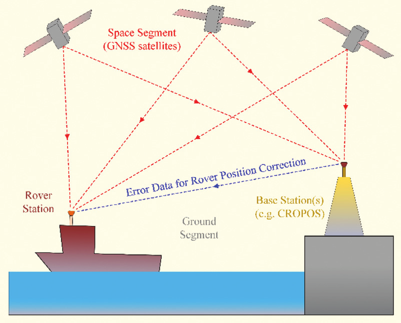
Image Credit: David Brčić et al.: Illustration showing Integration of GNSS and RTK systems for maritime applications.
Impact and risks
Space weather impose safety risks and operational challenges. Disruption to communication and navigation systems increase safety risks for mariners and can impact emergency response systems. The disruption of High Frequency (HF) and Very High Frequency (VHF) Radio and navigation causes cascading issues within the maritime vessels itself and its surrounding environment, leading to safety, environmental, legal and operational issues.
A disruption within the communication system means that operators no longer can use the Automatic Identification System (AIS), which effects situational awareness capabilities and vessel tracking, leading to higher risk of safety and security issues, a lack of operational efficiency, legal and commercial issues, lack of situational awareness, minimized of capabilities within collision avoidance maneuvers, increased issues caused by human error, worse decision-making, unable of early hazard detection, decreased adaptability, and higher dependency on strong communication and teamwork.
A disruption within the Global Navigation Satellite System (GNSS) and the Global Positioning System (GPS) means inaccurate or no help with navigation, route planning, and collision avoidance maneuvers.

Image Credit: M-maritime.
Source
Fiori, Robyn (2022): “Development of space weather services to inform maritime users of space weather events affecting high frequency radio communication”. 44th COSPAR Scientific Assembly. Held 16-24 July, 2022. Volume 44. Online at https://www.cosparathens2022.org/. Abstract PSW.1-0001-22. Pp. 3435.
Grant, Alan; Shaw, George (2012): “The effect of space weather on maritime aids-to-navigation service provision”. Annual of Navigation. Vol. 19(1). DOI: https://doi.org/10.2478/v10367-012-0005-9?urlappend=%3Futm_source%3Dresearchgate
Xue Dabin et al. (2024): “Space weather effects on transportation systems: A review of current understanding and future outlook”. Advancing Earth and Space Science (AGU). Volume 22, Issue 12. DOI: https://doi.org/10.1029/2024SW004055
Ishii, Mamoru et al. (2024): “Space weather impact on radio communication and navigation”. ELSEVIER. Advances in Space Research. DOI: https://doi.org/10.1016/j.asr.2024.01.043
NOAA (n.d.): “HF Radio communication”. https://www.swpc.noaa.gov/impacts/hf-radio-communications#:~:text=Space%20weather%20can%20impact%20HF%20radio%20communication,enhanced%20D%2Dlayer%20that%20blocks%20HF%20radio%20communication.
Danish Maritime Authority (n.d.): “AIS data”. https://www.dma.dk/safety-at-sea/navigational-information/ais-data
Hansen, Nicholas (2023): “Situational Awareness for autonomous marine vessels”. Technical University of Denmark (DTU). https://backend.orbit.dtu.dk/ws/portalfiles/portal/338331238/PhD_thesis_260_sider_-_76_farvede.pdf
WindWard (n.d.): “Automatic Identification Systems (AIS)”. https://windward.ai/glossary/what-is-automatic-identification-systems-ais/
SKYFI (n.d.): “Vessel tracking: keeping ships on course with moderns technology”. https://skyfi.com/en/blog/vessel-tracking-keeping-ships
Maritime Fairtrade (2024): “Navigating safety: importance of martine vessel tracking systems”. https://maritimefairtrade.org/navigating-safety-importance-of-marine-vessel-tracking-systems/
Maljković, Mislav et al. (2022): ”Situational Awareness from the master point of view and importance of factors that influence it”. ResearchGate. Conference ICTS 2022. https://www.researchgate.net/publication/361735423_SITUATIONAL_AWARENES_FROM_THE_MASTER_POINT_OF_VIEW_AND_IMPORTANCE_OF_FACTORS_THAT_INFLUENCE_IT